

We’ve been working on a feature for our website over the past few weeks that should make planning your next long-distance hike much easier: The display of all “Point-of-Interest” (POI) along the trails!
The handling is very simple! You search the long-distance hike of your choice in our database and go to the map of the trail. In the lower left corner you will now find the “Point-of-Interest” function. When you click on it, a small menu opens with a selection of categories:
- Accomodation
- Meals
- Shopping facilities
- Places of interest
- Emergency
- Traffic
- Infrastructure
Each category in turn contains sub-items (such as hotel, cottage, campsite, restaurant, supermarket,…), which then correspond very specifically to the points on the map.
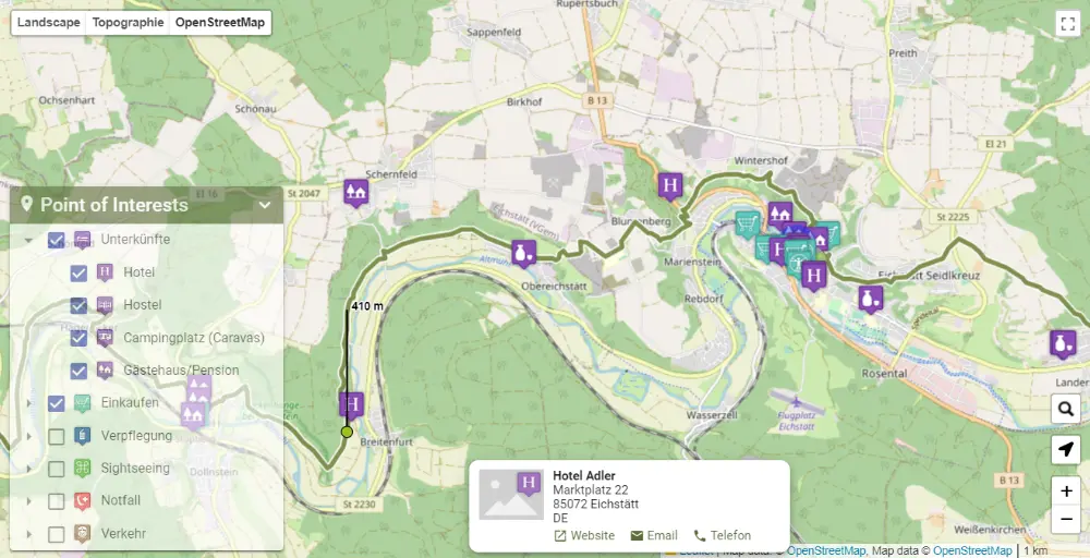
It is important to know that categories and sub-items are only displayed if there are corresponding locations along the trail. So don’t be surprised if a certain category is missing in the overview! It simply means that the search for places in this category was unsuccessful.
For the POI search we have created a corridor with a width of 3 km, which is exactly oriented to the path. In concrete terms, this means that only POIs that are no more than 1500 m of linear distance away are listed. The listing of places is intended to be informative only! Unfortunately, we cannot guarantee that the POI still exists and is open. It is also possible that the POI information is outdated. If it is a very important place for your adventure (for example, the only supermarket for the next five days), it is highly recommended to contact the supermarket and check its existence and opening hours. The same applies, of course, to all other places that are relevant for your trekking tour.
At the moment this function is only active for our existing trails. However, we are working on it so that you can upload GPX files yourself in the future and have them evaluated for important places along the trail. This way you can plan your adventures even better and faster in the future.