
If you’ve ever searched for trekking options in Western Europe, you’ve likely come across one of these long-distance hiking trails before. In fact, our trail database features several of these GR trails. In this blog article, you’ll learn all about these long-distance hiking trails, including how the GR routes came to be, and much more. We’ll also share our top 5 picks for the most unique and beautiful GR routes for your next long-distance trekking tour.
Table of Contents
What are the GR routes exactly?
The GR trails are a network of long-distance hiking trails in Europe, primarily passing through France, Belgium, Spain, and the Netherlands. The GR trails are a network of long-distance hiking trails in Europe, primarily passing through France, Belgium, Spain, and the Netherlands. Since these trails originated in France, the abbreviation is French and stands for (Sentier de) Grande Randonnée, which translates to “great hike” or “long-distance hike” in English. In the Netherlands, the GR trails are called Lange-afstand-wandelpaden, while in Spain they are called Gran Recorrido.
Generally, GR routes are labeled with numbers. However, because the maintenance of the trails is managed by different organizations, this numbering does not follow a uniform standard. As a result, there are trails in different countries that bear the same number, but do not connect to each other. Certain GR routes are included in the 12 European long-distance paths, also referred to as E-paths, each spanning thousands of kilometers.
The GR trademark is legally protected and the routes themselves are considered intellectual property. As a result, it can be difficult to find the precise route online for transnational long-distance routes. An overview of all French GR trails can be found here.
Trail Markings
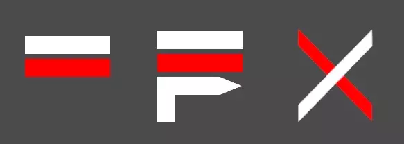
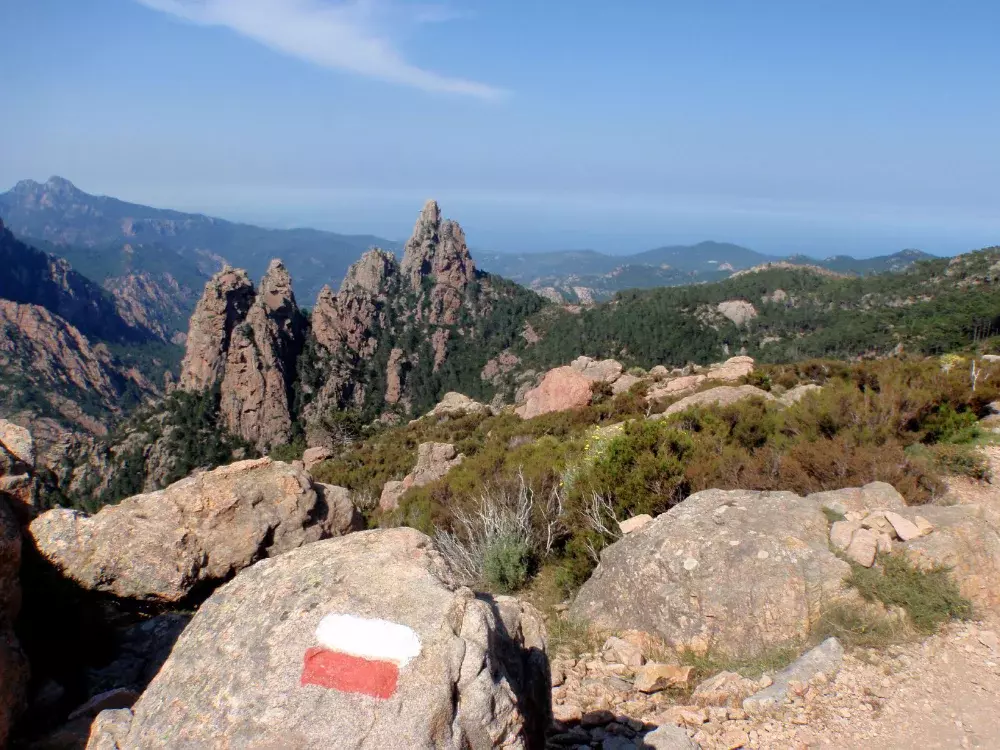
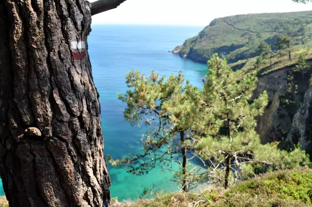
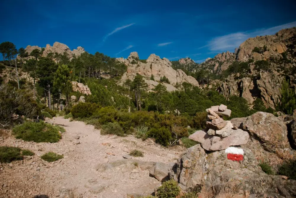
For the marking scheme of the GR trails, the colors red and white are used across countries. The two horizontal stripes stacked on top of each other (first symbol) indicate the hiking trail and confirm that you are on the right path. The next symbol, two horizontal stripes with an arrow underneath, signifies a change in direction. You must then turn in the direction of the arrow (illustrated here as a right turn). Crossed lines mean “wrong direction” or “wrong turn”.
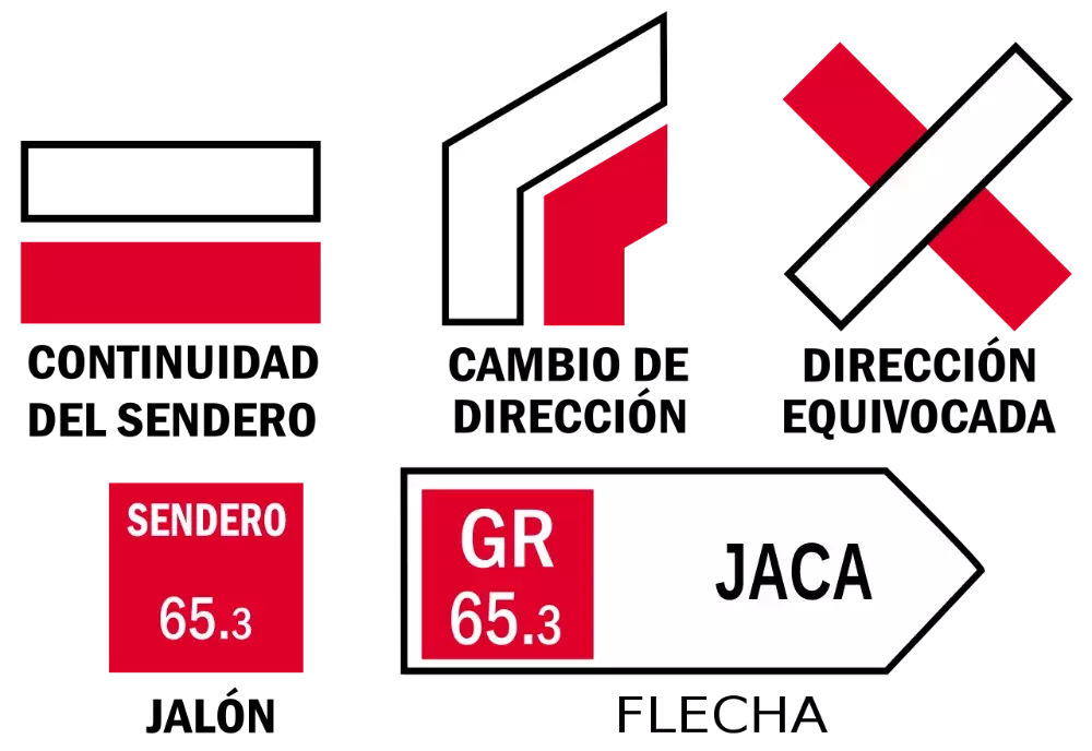
The markings shown in the first graphic are primarily used in France. In other countries, the markings for indicating a change in direction may differ. In Spain, for example, they usually look like the ones shown in this picture.
The History of the GR Routes
The Beginning of Hiking in France
Here, we need to go back a bit. Hiking is undoubtedly the oldest sport in the world However, hiking as a leisure activity did not become fashionable in Europe until the end of the 18th century with the Romantic era. Nature played a significant role in the art and literature of this period. It was considered a place of yearning and a counterbalance to the industrialized, overcrowded cities. More and more people are drawn to the vastness of nature.
This change led to the emergence of the first associations and clubs for hiking tourism in France in the second half of the 19th century, such as the Touring Club de France. In the early 20th century, the first scouting movements were established, followed by the youth hostel associations These clubs and organizations arrange hiking expeditions, mainly for young people, during which a region is explored on foot for several days. For instance, the Club Alpin Français (CAF) has been organizing hikes in the Fontainebleau forest since 1910.
Jean Loiseau: The Man Behind the GR Trails
On one of these trips, Jean Loiseau, who was only 14 years old at the time, discovered his love for nature and hiking. At 15, he became a troop leader with the Scouts and began putting together his own hiking programs. In the years that followed, Loiseau, who worked as an archivist at the Banque de France, traveled across Europe and upgraded his camping equipment.
In 1928, he formed a group of hikers called Les Compagnons Voyageurs (Travel Companions), recruiting members primarily from the youth of the Touring Club de France. All of them were adept at navigating nature using a compass and map, and they explored the paths of France and Europe together. Starting in the 1930s, Loiseau shared his extensive knowledge through a series of books. His book, Camping et voyage à pied (Camping and Traveling on Foot), became a sort of bible for camping and hiking enthusiasts.
The New Interest in Hiking
Despite this, hiking as a leisure activity remained relatively unknown, mainly because most people had very little free time However, this all changed due to a development in labor law in France: in 1936, the 40-hour workweek was introduced, and every employee was granted the right to paid vacation days for the first time.
As a result, there was a sudden surge of interest in hiking. The surge of interest among the population motivated Loiseau to create a network of long-distance hiking trails in France, allowing even those with little experience to enjoy hiking without the fear of getting lost. He provided a detailed description of this long-distance hiking network in his book Les Routes du marcheur (The Walker’s Routes) as early as 1938.
From the grandes routes du marcheur to the Grande Randonnée
During the war, Loiseau developed a concept for his grandes routes du marcheur (long-distance walking routes) project with the help of the Camping Club de France. In 1945, they presented the project to the influential Touring Club de France. The club was thrilled with the concept and decided to immediately realize it.
By the end of 1946, a master plan for the network of long-distance hiking trails had been developed and approved. The plan also established a system of standardized trail markings. Loiseau drew inspiration from the trail markers used in the US Appalachian Park, which featured colored stripes on trees and rocks to guide hikers. It’s said that he took inspiration for the colors from French foresters, who used red markings to designate areas for logging. He added the white stripe to ensure that the trail could still be visible even in low-light conditions.
A recruitment of volunteers to mark the trails is taking place within the hiking clubs and associations. The grandes routes du marcheur (great walking routes) quickly became known as the Grande Randonnée (Great Trails). By the beginning of 1947, construction had already begun on several sections of the future GR trails.
On August 22 of that same year, at Loiseau’s initiative, the Comité National des Sentiers de Grande Randonnée (CNSGR), or National Committee of GR Trails, was founded from the participating clubs and associations. Many members of this group of hikers were personally trained by Loiseau and were responsible for marking and maintaining the trails from then on.
Opening of the First GR Path
In August 1947, the long-awaited moment finally arrived: a symbolic section of the GR3 from Orléans to Beaugency, spanning 28 km, was inaugurated as France’s first long-distance hiking trail. Interestingly, in 2023, this GR trail is a whopping 1311 km long. The following year, the GR1 in the Île-de-France region was next in line. In the same year, the first section of the long-distance hiking trail was inaugurated between Dammartin-en-Goële and Orry-la-Ville.
Further Development of the GR Network
In 1951, the legendary Tour du Mont Blanc (TMB) was completed, and the following year saw the existence of 1,000 km of GR trails. Over the next few years, several thousand kilometers of long-distance hiking trails were marked by volunteers, and the trail network continued to expand and gain popularity.
The decision of the IGN (National Geographic Institute of France) in 1956 to include long-distance hiking trails in their maps may have also contributed to the popularity of the GR trails. The first of the still very popular Topo-Guides was published in 1957.
Founding of the FFRP
Due to the constant expansion of the network of trails into more and more regions and the increasing number of hikers, it was decided to restructure the organization. Therefore, in 1978, the CNSGR was transformed into the umbrella organization FFRP (Fédération Française de la Randonnée Pédestre), which today includes more than 3,050 individual hiking clubs. The organization is to this day dedicated to the maintenance of the GR routes and the promotion of hiking.
The Origins of the GR Routes in Belgium, Spain, and the Netherlands
In 1959, the idea was exported to Belgium by three Belgians vacationing in Provence and the ambitious project of the GR5 was launched. It aimed to create a long-distance hiking trail from the North Sea to the Mediterranean. Today, the GR trails in Belgium are managed by the non-profit organization Sentiers de Grande Randonnée (SGR).
In Spain, the history of the GR trails begins in the early 1970s. The mountaineering association FEDME (Federación Española de Deportes de Montaña y Escalada), which still manages the trails today, receives a request from French tourism associations to expand the GR trails on the Spanish side. Especially the GR7 is to be extended to the west. This trekking route now leads from France through Andorra to Tarifa in Andalusia, with a continuation on the Canary Islands in the form of the GR131. As of 2023, there are over a hundred GR routes in Spain.
In the 1970s, the Netherlands also developed the idea for a network of long-distance hiking paths. These trails are not referred to as GR routes, but rather as Lange-afstand-wandelpaden (LAW), and they are not directly linked to the Grande Randonnée routes. The creators of the most famous trekking route in the country, the Pieterpad, Toos Goorhuis-Tjalsma and Bertje Jens, were not inspired by the French long-distance hiking trails, but by their hikes in the German Black Forest.
Nonetheless, the LAWs are often considered part of the GR network, not least because some of the LAWs connect to the GR long-distance hiking trails. For example, the GR5 intersects with the Pieterpad near Maastricht. Also, the trail markings are very similar. In addition to the LAWs, several international GR routes also pass through the Netherlands, including the aforementioned GR5, GR12, GR16, GR17, and GR128.
Our Top 5 GR Routes
Are you looking for a long-distance hiking trail for your next trekking adventure? You’ve come to the right place! We would like to present you our top 5 most extraordinary and beautiful GR hiking trails. With different difficulty levels and landscapes (do you want to hike along the coast or in the mountains?), every trekking enthusiast will find something to suit their preferences!
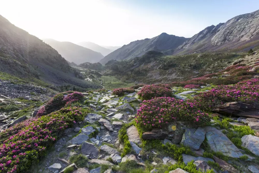
GR20 One of Europe’s Toughest Long-Distance Hiking Trails
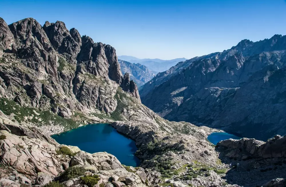
The GR-20, established in 1972, runs through the French island of Corsica and is not only the most well-known GR trail, but also the most challenging. With constant ups and downs, sudden weather changes, and rocky terrain on steep, narrow paths, the GR20 presents a real challenge for all trekking enthusiasts. In total, you will have to climb almost 12,000 meters in altitude. The lowest point of the trail is 250 meters above sea level, while the highest point reaches a staggering 2,500 meters. Depending on your fitness level, you will need about 16 days to complete this 181-kilometer long long-distance trail.
Trail creator Michel Fabrickant was inspired by Jean Loiseau’s book Itinéraires de Corse (Travel Routes in Corsica), in which he documented the paths of his hikes on Corsica. The 180 km long GR-20 leads over 15 stages across the Corsican high mountains from Calenzana in the north to Conca in the south of the island.
Along the way, there are many highlights, such as the deep blue glacial lakes of Capitellu and Melo or Corsica’s highest mountain, the Monte Cinto, at 2706 m altitude. You can stay overnight in mountain huts along the trekking route. Generally, this trail can be hiked at any time of the year, but the easiest time is between June and October when the majority of the path is free of ice.
GR21 – The Relaxed One
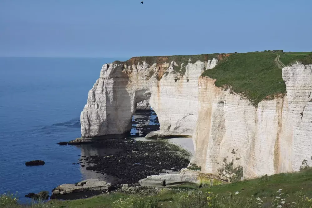
The GR21, also known as Littoral de Normandie, takes you along the Normandy coast. In 2019, this trail was voted the most popular long-distance hiking trail in France in an FFRP survey. Starting in the UNESCO World Heritage town of Le Havre, the trail mostly follows the Normandy coast with its up to 110m high chalk cliffs. These famous cliffs have earned the coast the name Alabaster Coast. The 189km long trail ends in the port city of Le Tréport.
The GR21 not only takes you through the stunning landscapes of Normandy, past the chalk cliffs, green meadows, and fields, but also offers plenty of cultural attractions. From the trail, you’ll have a good view of the Étretat lighthouse, built in the 19th century. Directly next to the long-distance hiking trail is the Château de Dieppe, which towers over the city on a hill and now houses a museum. We recommend the months of March through November as the ideal time to embark on this trekking tour. The weather in Normandy can be quite changeable even in the summer months, so be sure to pack weatherproof clothing and shoes.
The highest point of this long-distance hiking trail is just 130 meters above sea level, and the paths are well-developed, with some sections even paved. herefore, we recommend the flat coastal path mainly for beginner trekkers. You’re never far from the next coastal town, where you can buy groceries. Unfortunately, wild camping is not allowed, but you can pitch your tent at numerous campsites along the trail or simply stay overnight at hotels and guesthouses dotted along the hiking route.
GR5 – From the North Sea to the Mediterranean
The GR5 is one of the longest and most impressive Grandes Randonnées. This long-distance hiking trail spans a total of 2080 km from the North Sea to the Mediterranean. In its longest variant, it begins at the Dutch coast in Hoek van Holland, passes through Belgium and Luxembourg, and finally ends in the French port city of Nice.
This trek was deliberately designed to cross and touch as many mountain ranges as possible. During your hiking tour, you can enjoy the beauty of the Ardennes, Vosges, Jura Mountains, and the Alps. The numerous ascents and descents in the mountains make the GR5 a challenging adventure. To complete the entire route at an average pace, you will need over 3 months (of course, you can also hike sections of it).
In return, the trail rewards you with beautiful and varied landscapes. You will encounter a wide range of mountain landscapes, from high alpine peaks to gentle hills. The hiking trail passes through dense forests that stretch over the Vosges and Jura mountains, over vineyards in the Burgundy region of France, and up to glaciers and high peaks in the Alps, where you’ll walk past blooming alpine meadows in the summer.
The last section of this trekking tour is probably also the most famous. The last section of this trekking tour is probably also the most famous. From the southern shore of Lake Geneva, the Grande Traversée des Alpes (GTA; Great Alpine Crossing) leads through the landscape of the French Alps to Nice. Along this section of the trail, many highlights await you, such as the Mont Blanc massif or the Vanoise National Park.
GR11 – Discover the Pyrenees
The GR11, also known as the Ruta Transpirenaica (Trans-Pyrenees Route), runs for a length of 827 kilometers through France, Spain, and Andorra. It winds its way from the French Atlantic coast to the Mediterranean in Catalonia. Embarking on a trekking tour along the GR11 takes you along the entire Spanish side of the Pyrenees.
Although less known than the Alps, this mountain range is by no means less impressive. On this long-distance hiking trail, you’ll climb a new peak of the 430-kilometer-long mountain chain almost every day, and then descend into the valley. This trail rewards you with stunning views, but the over 40,000 meters in altitude to conquer and the narrow, rocky paths make it a trail best suited for experienced hikers.
The best time to trek on the GR11 is from June to September, but even then, there may still be snow and ice in the higher altitudes. For instance, in August, there is often still snow in the slopes leading from Refugio de Respomuso to Cuello Tebarrai (2782 m).
During the summer months, the Pyrenees landscape is particularly beautiful. Your trekking tour will take you through the deepest gorges in Europe, which house many endangered species of animals and plants that are extinct elsewhere. Along the long-distance hiking trail, you will encounter not only the rugged beauty of rock formations, but also blooming mountain meadows, crystal-clear mountain lakes, streams, and waterfalls. The GR11 leads you along remote mountain paths through areas far away from civilization, as well as through small mountain villages, past dolmens, Romanesque chapels and monasteries, medieval castles, and bunkers from the Spanish Civil War. On the trail, you can experience the region’s eventful history up close.
There are guarded mountain huts, called refugios, available for overnight stays. If you prefer camping outdoors, you can also go wild camping during your trek. Although it is officially prohibited, it is usually tolerated.
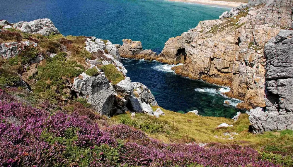
GR34 – Tracing the Footsteps of the Customs Officers
The GR34, also known as the “Customs Officer’s Path” or “Sentier des Douaniers”, is a beautiful and historically rich long-distance trail that runs along the coast of Brittany.
The origin of the path dates back to the 18th century. Back then, customs officers patrolled this path day and night to make life difficult for smugglers. In the 20th century, the path fell into oblivion. Fortunately, with the emergence of long-distance hiking trails, it was rediscovered and has since become very popular with trekkers from all over the world.
On this approximately 2000 km-long coastal path (depending on the variant, it may be slightly longer or shorter), you can experience the beauty of Brittany up close during your trekking tour. Here, the sea is always in sight. You will walk along rocky headlands and rugged cliffs, but you will also find numerous sandy beaches and coves inviting you to take a swim. It is especially beautiful in spring and summer when the flowers start to bloom on the meadows beside the coast. If you’re looking for solitude on the trail, you should plan your hike for autumn. The GR34 has many highlights, including the Crozon Peninsula, the Pink Granite Coast Côte de Granit Rose in the north, and the Emerald Coast (Côte d’Emeraude) between Cap Fréhel and the town of Cancale, named after its emerald green waters.
This long-distance hiking trail is perfect for novice trekkers. However, you should have a head for heights, as the trail passes very close to the cliffs in many places. Along the trail, you will come across small and large coastal towns where you can stock up on supplies every day. Unfortunately, wild camping is not allowed on this trekking route. Similar to the GR21, you can stay at numerous campsites or hotels and guesthouses along the way.
Conclusion
The GR routes are perhaps the most impressive long-distance hiking network in Europe. They cover over 100,000 kilometers in total, spanning across France, Spain, Belgium, and the Netherlands. Whether you prefer adventurous routes through the mountains or leisurely hikes along the coast, there’s something for everyone!
If you need more information, be sure to check out our trail search where you can find everything you need to know about 13 of the GR trails for your trekking adventures.